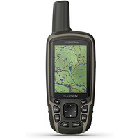


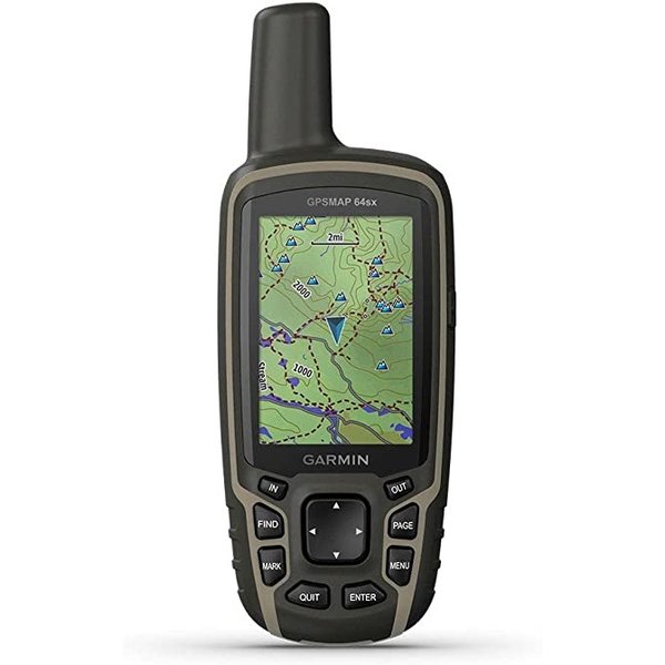
Explore the World with Reliable Navigation in Hand
- Rugged and water-resistant design with button operation and a 2.6” sunlight-readable color display
- Preloaded with TopoActive maps featuring routable roads and trails for cycling and hiking
- Know where you’re at with a high-sensitivity receiver with quad helix antenna and multi-GNSS support (GPS, GLONASS and Galileo) and 3-axis compass with barometric altimeter
- Wireless connectivity via BLUETOOTH® technology and ANT+® technology available on GPSMAP 64sx and GPSMAP 64csx models
- GPSMAP 64csx adds 8-megapixel autofocus camera that lets you geotag photos
- Battery life: up to 16 hours in GPS mode
General | |
| PHYSICAL DIMENSIONS | 2.4" x 6.3" x 1.4" (6.1 x 16.0 x 3.6 cm) |
|---|---|
| DISPLAY SIZE | 1.43" x 2.15" (3.6 x 5.5 cm); 2.6" diag (6.6 cm) |
| DISPLAY RESOLUTION | 160 x 240 pixels |
| DISPLAY TYPE | transflective, 65K color TFT |
| WEIGHT | 7.7 oz (217 g) with batteries |
| BATTERY TYPE | 2 AA batteries (not included); NiMH or Lithium recommended |
| BATTERY LIFE | 16 hours |
| WATER RATING | IPX7 |
| HIGH-SENSITIVITY RECEIVER | |
| INTERFACE | high speed mini USB and NMEA 0183 compatible |
| MEMORY/HISTORY | 8 GB (user space varies based on included mapping) |
Maps & Memory | |
| PRELOADED MAPS | yes (TopoActive; routable) |
|---|---|
| ABILITY TO ADD MAPS | |
| BASEMAP | |
| AUTOMATIC ROUTING (TURN BY TURN ROUTING ON ROADS) | |
| MAP SEGMENTS | 3000 |
| BIRDSEYE | 250 BirdsEye Imagery files |
| INCLUDES DETAILED HYDROGRAPHIC FEATURES (COASTLINES, LAKE/RIVER SHORELINES, WETLANDS AND PERENNIAL AND SEASONAL STREAMS) | |
| INCLUDES SEARCHABLE POINTS OF INTERESTS (PARKS, CAMPGROUNDS, SCENIC LOOKOUTS AND PICNIC SITES) | |
| DISPLAYS NATIONAL, STATE AND LOCAL PARKS, FORESTS, AND WILDERNESS AREAS | |
| EXTERNAL MEMORY STORAGE | yes (32 GB max microSD™ card) |
| WAYPOINTS/FAVORITES/LOCATIONS | 5000 |
| TRACKS | 200 |
| TRACK LOG | 10000 points, 200 saved tracks |
| ROUTES | 200, 250 points per route; 50 points auto routing |
Sensors | |
| GPS | |
|---|---|
| GLONASS | |
| GALILEO | |
| BAROMETRIC ALTIMETER | |
| COMPASS | Yes (tilt-compensated 3-axis) |
| GPS COMPASS (WHILE MOVING) | |
Daily Smart Features | |
| VIRB® REMOTE | |
|---|---|
| PAIRS WITH GARMIN CONNECT™ MOBILE | |
| SMART NOTIFICATIONS ON HANDHELD | |
Outdoor Recreation | |
| POINT-TO-POINT NAVIGATION | |
|---|---|
| COMPATIBLE WITH BASECAMP™ | |
| AREA CALCULATION | |
| HUNT/FISH CALENDAR | |
| SUN AND MOON INFORMATION | |
| GEOCACHING-FRIENDLY | Yes (Paperless) |
| CUSTOM MAPS COMPATIBLE | yes (500 custom map tiles) |
| PICTURE VIEWER | |
Connections | |
| WIRELESS CONNECTIVITY | yes (BLUETOOTH®, ANT+®) |
|---|---|